About Doi Inthanon National Park
Inthanon National Park is located in the Mae Chan district of Chiang Mai province, 60 kilometers from Chiang Mai city, and is known as the “roof of Thailand” because of the location of Mount Inthanon, the highest mountain in Thailand. Established in 1972, the park covers an area of 482 square kilometers and is a national park with beautiful scenery and diverse flora and fauna.
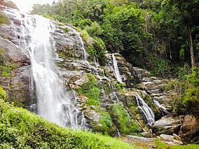
Inthanon National Park is home to lush forests, cascading waterfalls, mysterious caves, bright flowers, lively animals and a hard-working and simple race of people, about 4,500 of whom live in the park and play a major role in the conservation of this area. When you climb the mountain, the light mist around you will make you feel as if you are in a fairyland, and when you reach the top of the mountain, the clouds will clear and you will see the end of the sky. There are many spectacular waterfalls and magical caves in the park, such as Mae Klang Waterfall and Brichinda Cave.
Inthanon National Park is an excellent bird watching destination, with its wide mountain ranges and cool climate suitable for a wide variety of birds. 362 species of birds have been recorded and are still increasing, many migrating from northern Asia, with a rich variety of species.
How to get there
Ban Luang Chom Thong, Chiang Mai 50160
Tips
It was 50 km from Chiang Mai to the foot of Mount Inthanon, and another 50 km from the trail at the foot to the summit, a convenient one-way trip of about 100 km (about 2 to 2.5 hours).
The entire Doi Inthanon National Park was well maintained.
The road was well paved all the way to the top.
The highest peak in Thailand is easy to drive around.
There are stores and restrooms at tourist spots.
However, the temperature is quite different from the lower areas, so you need to bring a sweater.
Web page


Stay in Bangkok